
Digital as-built survey for reliable planning
Project Overview
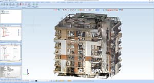
A multi-storey residential building in Tbilisi, Georgia, was fully captured using 3D laser scanning, covering both interior and exterior areas.
The objective was to create a complete and reliable digital as-built documentation to serve as a foundation for architectural modifications, trade coordination, and subsequent refurbishment and execution phases.
The resulting point cloud represents the entire building geometry with high accuracy and enables seamless further processing in modern CAD and BIM environments.
Initial Situation
Existing building documentation was incomplete and partially inconsistent.
For the upcoming planning and interior design processes, a precise digital basis was required that could:
- provide exact dimensions, axes, and building geometries
- reveal shafts, installation zones, and routing of technical services
- accurately represent room geometries and height levels
- identify deviations between existing conditions and legacy drawings
Without a reliable as-built dataset, secure planning would not have been possible.
Laser Scanning Execution
The entire building was recorded in multiple stages using a FARO laser scanner. The scope included:
- façades and external building envelope
- all floors, rooms, stairwells, and balconies
- installation shafts, building services, and relevant fixtures
- roof structures and technical levels
- terrain interfaces and surrounding areas
All scan positions were registered into a unified, colourised point cloud that fully documents the real-world condition of the building.
CAD Processing and Data Preparation
The point cloud was imported into HiCAD and used as the basis for:
- generation of accurate as-built drawings
- trade-specific data extraction according to client requirements
- collision checks and geometric validation
- detailed component-based modelling for architects and interior designers
- The processed data was delivered in a structured format to the client and all project partners.
Project Collaboration
A key aspect of this project was its international team structure, with multiple disciplines working from different locations.
By creating a comprehensive digital twin, all stakeholders were able to:
- access identical, verified as-built data
- plan without geometric uncertainties or collisions
- make coordinated decisions across locations
- align individual trades efficiently
- work without measurement errors or assumptions
This established a stable framework for professional collaboration despite geographical separation.
International Workflow & Digital Precision
This project demonstrates how modern 3D capture technologies enable distributed planning workflows:
- Captured on site in Georgia
- Processed and modelled in Austria
- Used by architects, planners, and contractors at multiple locations
The result is a consistent digital twin of the building, providing a reliable basis for refurbishment, extensions, modernisation, and interior design concepts.
Conclusion
The complete building scan delivered the level of data accuracy required for safe and reliable planning decisions.
By combining high-resolution point cloud data with precise CAD processing, the client received a robust digital building model that provides clear geometric orientation for all project participants and significantly reduces planning risks.